3.1 Overall number of households and dwellings
Table 1 shows the number of households in each local authority area in Scotland from 1991 to 2007, and Table 2 shows the number of dwellings.
A dwelling is a self-contained unit of accommodation such as a flat or house, and a household is one person or a group of people living together at the same address. The number of households will be smaller than the number of dwellings, as some dwellings are vacant, or second homes. Some further adjustments are made to the figures on households – for more information, and definitions, refer to Section 4.
These tables show the following trends:
3.2 Characteristics of dwellings
Tables 3, 4 and 5 show the number of dwellings by Council Tax band, type of dwelling (flat, terraced, semi-detached or detached), number of rooms per dwelling, and density of housing.
These figures are summarised by urban/rural classification in Table 3 (according to the Scottish Government 6-fold urban/rural classification), by level of deprivation in Table 4 (according to the Scottish Index of Multiple Deprivation), and by local authority area in Table 5. Background information on the population by age group is included in Tables 3 and 4.
These tables highlight the following trends:
3.3 Characteristics of households
Tables 6, 7 and 8 show the percentage of dwellings which are occupied, vacant or second homes. They include the percentage of dwellings entitled to a Council Tax discount because they are occupied by one adult (living alone or with children, or with other adults who are ‘disregarded’ for Council Tax purposes). They also show the percentage of dwellings which are occupied but exempt from paying Council Tax, such as households entirely occupied by students, or armed forces accommodation.
These figures are summarised by urban/rural classification in Table 6, by level of deprivation in Table 7, and by local authority area in Table 8.
These tables highlight the following trends:
3.4 Variation within local authority areas
Most of the tables in this publication show information at local authority level. Some of this information is also illustrated by maps. Map 1 shows the percentage of dwellings in each local authority area which are flats. Urban areas, and areas closer to the ‘Central Belt’ of Scotland, tend to have higher proportions of flats. Map 2 shows the percentage of dwellings in each local authority area which are vacant – in general, it is the more rural areas and the island authorities which have the highest proportions of vacant dwellings. Dundee City and Inverclyde also have relatively high proportions of dwellings which are vacant.
These figures illustrate the wide variations between local authority areas. However, there can also be a great deal of variation within a local authority area, which is not shown in these tables and maps. The Scottish Neighbourhood Statistics (SNS) website www.sns.gov.uk, contains statistics for each ‘data zone’ in Scotland, which is a standard geography used for a range of statistics. The average data zone contains around 750 people, which is small enough to provide quite detailed local information, and can be aggregated to different areas of interest. The information summarised in this publication is available at data zone level, from the SNS website. This includes the number of dwellings by Council Tax band, type of dwelling, number of rooms per dwelling, density of housing, and the percentage of dwellings which are occupied, vacant, second homes, or are entitled to a ‘single adult’ Council Tax discount, or an ‘occupied exemption’. The SNS website allows users to view tables or maps for individual areas, or to download all the data in order to analyse it further.
Maps 3, 4 and 5 illustrate the types of information that can be produced using the SNS website.
Map 3 shows the percentage of dwellings which are flats in each data zone, in Glasgow and the surrounding local authority areas. This shows that more of the dwellings in urban areas are flats, as has been shown previously.
Map 4 shows the percentage of dwellings which are second homes, in the area within and surrounding the Cairngorms National Park. This demonstrates that there are higher proportions of second homes in and around the National Park, than in most of the outlying areas.
Map 5 shows the percentage of dwellings with ‘occupied exemptions’, in and around Edinburgh. This gives an illustration of the two main types of dwellings which are occupied but exempt from paying Council Tax – the area in the centre of Edinburgh contains relatively high numbers of all-student households, and there are also areas outside the city which contain armed forces accommodation.
Maps 3, 4 and 5 provide useful illustrations of the data, but it is not possible to include data zone maps for every part of Scotland within this publication (though users can produce their own maps at www.sns.gov.uk). An alternative way of illustrating the variation within a local authority area is through the use of boxplots.
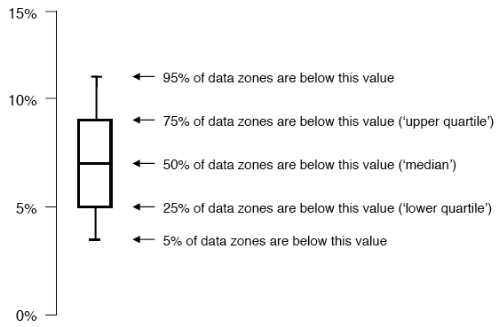
Figures 1, 2, 3 and 4 use boxplots to illustrate the variation within each local authority area. Boxplots show the middle ranked data zone, and they also show the level of variation – the larger the box, the more variation there is within that local authority area. An illustration of a boxplot is shown below.
Example of a boxplot (the percentage of dwellings which are vacant, in each data zone in Eilean Siar)
The example given above shows the percentage of dwellings which are vacant in each data zone in Eilean Siar (from Figure 1). This shows that in half the data zones in Eilean Siar, up to 7 per cent of dwellings are vacant, but there is a reasonable amount of variation across the local authority area. In the 5 per cent of data zones with the lowest figures, fewer than 3 per cent of dwellings are vacant, while in the 5 per cent with the highest figures, more than 11 per cent of dwellings are vacant.
Figures 1, 2, 3 and 4 show boxplots of each council area, showing the percentage of dwellings which are vacant, are second homes, have ‘single adult’ discounts, or ‘occupied exemptions’. These charts illustrate a number of trends, and confirm some of the trends seen in the previous tables:
3.5 Changes in household size and type
Table 9 and Figure 5 show information on changes in household size and type. Since 1991, Scotland’s population has increased by around one per cent. However, the number of households has increased at a far greater rate (by over 12 per cent), because the average household size is getting smaller, with more people living alone and in smaller households. Since 2001, the number of households containing just one adult has increased by eight per cent, and the number of two adult households increased by seven per cent. In contrast, the number of larger households (such as two or more adults with children), has decreased. This change in household size and type has led to an increase in the number of households in Scotland, despite relatively little change in the population.