4. Results for Administrative Areas
4.1 Population Change 2008-2009
4.1.1 Population estimates for each Council and NHS Board area, together with details of the components of population change (births, deaths, net migration and other changes) for the period mid-2008 to mid-2009, are shown in Table 2, Table 3 and Table 4.
4.1.2 Among Council areas, Aberdeen City had the largest percentage population increase at +1.6 per cent followed by City of Edinburgh (+1.3 per cent) and Perth & Kinross (+1.2 per cent). Seven councils experienced a decrease in population although the decreases were mainly very small. These were Inverclyde (-0.7 per cent), Argyll & Bute (-0.5 per cent), North Ayrshire (-0.3 per cent), South Ayrshire (-0.2 per cent) and Moray, Eilean Siar and Angus (all -0.1 per cent).
4.1.3 Of NHS Board areas, Grampian, Lothian and Shetland had the largest percentage population increases (all +1.0 per cent). The only NHS Board areas to have experienced a decline in population were Ayrshire & Arran and Western Isles (both - 0.1 per cent).
4.2 Components of Migration 2008-2009
4.2.1 For most areas, the main cause of population change in the year to mid-2009 was migration. Table 5 shows, for this period, migration flows to and from each Council and NHS Board area for people moving within Scotland (i.e. between one Council area and another or between one NHS Board area and another), people moving between Scotland and the rest of the UK and people moving between Scotland and overseas. In Table 5 and in Figure 5a and Figure 5b, movements to and from the armed forces are included in the rest of UK figures.
In- and out-migration
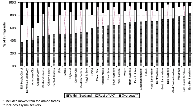
4.2.2 As Figure 5a shows, different Councils attract migrants from different areas. In some Council areas (such as East Renfrewshire, East Dunbartonshire, Midlothian, West Dunbartonshire, East Ayrshire and South Lanarkshire) most of the migrants came from other Council areas within Scotland. For example, of the 2,955 people estimated to have arrived in East Renfrewshire, 2,469 (about 84 per cent) were from elsewhere in Scotland, 344 (about 12 per cent) from the rest of the UK and 142 (about 5 per cent) were from overseas.
4.2.3 In other areas (such as Dumfries & Galloway, Orkney and Shetland) more than half of the migrants entering the area came from outside Scotland with most of these coming from the rest of the UK.
4.2.4 In most city authorities, City of Edinburgh, Glasgow City and Aberdeen City, the pattern was again for high proportions of migrants to come from outside Scotland with most coming from overseas.
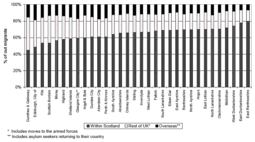
4.2.5 As Figure 5b shows, there are also differences in the destinations of people migrating out of Council areas. Often the region to which most out-migrants moved was the same region from which most in-migrants had arrived. For example most of the migrants leaving East Renfrewshire, East Dunbartonshire, West Dunbartonshire and Midlothian moved elsewhere in Scotland and, as described above, most of the migrants arriving in these Council areas came from elsewhere in Scotland.
Net migration
4.2.6 As Table 5 shows, as a result of these different patterns of both in- and out- migration, some councils experienced net gains from one region but net losses to another whilst others experienced gains from all areas.
4.2.7 In some Council areas more people arrived from each of the regions (within Scotland, the rest of the UK and overseas) than left. Other Council areas (Inverclyde and East Dunbartonshire) had a net loss of people to each region.
4.2.8 Council areas such as East Ayrshire, Scottish Borders and South Ayrshire had net gains from other areas within Scotland and from the rest of the UK, but lost more people than they gained from overseas.
4.2.9 The city authorities lost migrants to other areas of Scotland but tended to gain from the rest of the UK and, in particular, overseas. For example, there was a net gain of over 2,884 migrants in Aberdeen City, comprising a net loss of over 1,000 people to the rest of Scotland and net gains of over 300 people from the rest of the UK and nearly 3,600 people from overseas.
Figure 5a Origin of in-migrants by Council areas, 2008–2009, (ranked by increasing percentage of migrants from within Scotland)
Figure 5b Destination of out-migrants by Council areas, 2008–2009 (ranked by increasing percentage of migrants to within Scotland)
4.3 Population Change 1999-2009
4.3.1 Details of population changes in administrative areas between 1999 and 2009 are shown in Table 7. These changes are illustrated for Council areas in the map at Figure 6a and the chart at Figure 6b which both show the percentage change in the population of Council areas between 1999 and 2009.
Figure 6a Percentage change in population, Council areas, 1999-2009 (Map)
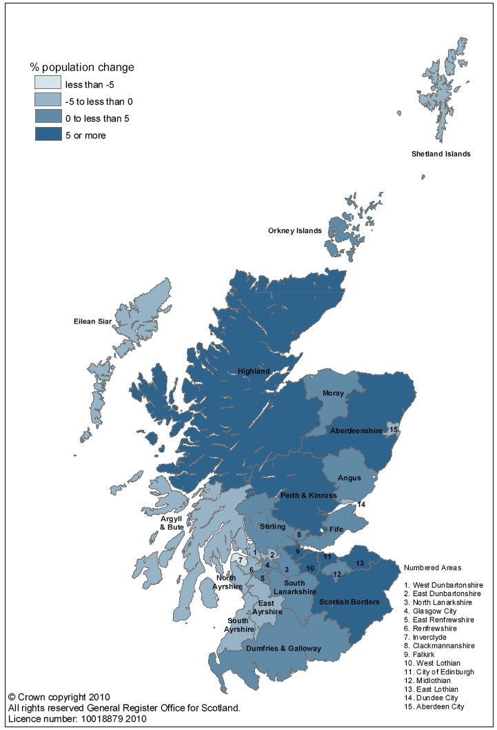
Figure 6b Percentage change in population, Council areas, 1999-2009 (Chart)
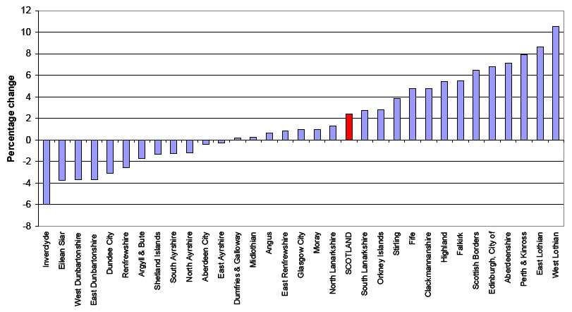
4.3.2 Between 1999 and 2009, the Council areas with the largest percentage population growth were West Lothian (+10.5 per cent), East Lothian (+8.7 per cent) and Perth & Kinross (+7.9 per cent). The largest absolute increase in numbers was in the City of Edinburgh (+30,470). Inverclyde (-6.0 per cent), Eilean Siar (-3.8 per cent), West Dunbartonshire and East Dunbartonshire (both -3.7 per cent) showed the greatest percentage decreases during this period. The largest absolute decrease in numbers was in Inverclyde (-5,090).
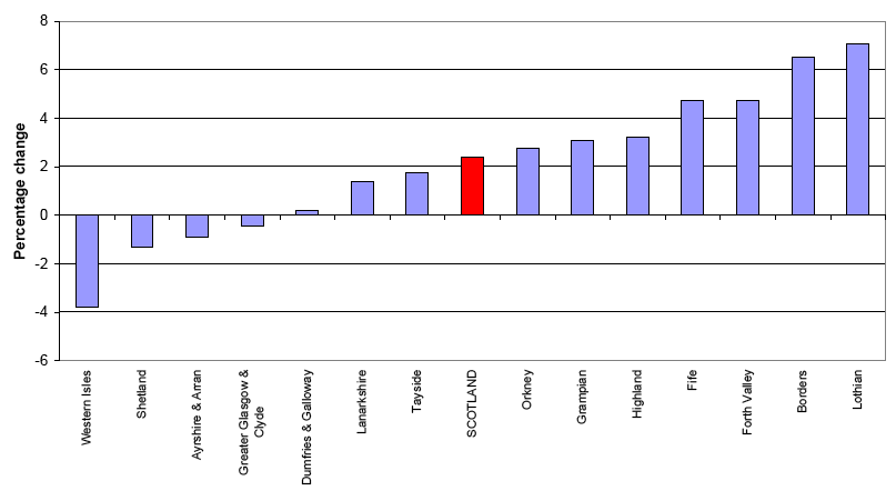
4.3.3 The map at Figure 7a and the chart at Figure 7b show the percentage change in population between 1999 and 2009 for each NHS Board area. The largest percentage increases in population were in Lothian (+7.1 per cent), Borders (+6.5 per cent) and Forth Valley and Fife (both +4.7 per cent). The greatest percentage decreases occurred in the Western Isles (-3.8 per cent) and Shetland (-1.3 per cent).
Figure 7a Percentage change in population, NHS Board areas, 1999-2009 (Map)
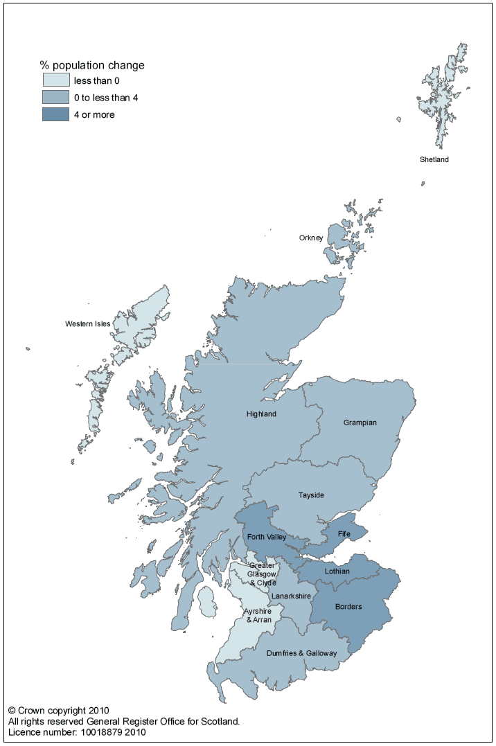
Figure 7b Percentage change in population, NHS Board areas, 1999-2009 (Chart)
4.4 Age and Sex Structure of Administrative Areas in Scotland
4.4.1 There were more women than men in Scotland in mid-2009 and this is the case for all Council areas other than Moray and Shetland Islands and for all NHS Board areas other than Shetland. Table 8 shows the "sex ratio" for each Council and NHS Board area in Scotland. The sex ratio is the male population divided by the female population (e.g. a sex ratio of 0.95 means that for every 100 females there are 95 males). The sex ratio ranged from 0.90 in North Ayrshire, Dundee City, Midlothian and West Dunbartonshire to 1.02 in Shetland Islands. For the NHS Board areas, the sex ratio ranged from 0.92 in Ayrshire & Arran to 1.02 in Shetland.
4.4.2 Though the pattern of age distribution is complex, some general themes can be seen from Table 8. Most city council areas had the highest proportions of men and women of working age1. For example, in City of Edinburgh 72 per cent of men and 64 per cent of women were of working age compared with 67 per cent of men and 59 per cent of women as a whole. The highest proportions of people of pensionable age2 tended to be in rural areas such as Dumfries & Galloway (20 per cent of men and 31 per cent of women) and Argyll & Bute (19 per cent of men and 32 per cent of women). In Scotland as a whole, 15 per cent of men and 25 per cent of women were of pensionable age.
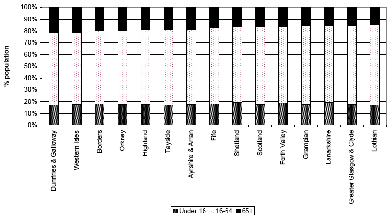
4.4.3 These patterns can also be seen in Figure 8 and Figure 9 which show the proportion of the population aged under 16, 16-64, and 65 and over for Council and NHS Board areas respectively (sorted by proportion of population aged 65 and over).
Figure 8 Age structure of Council areas, 30 June 2009 (% under 16, 16-64 and 65+), (ranked by percentage aged 65+)
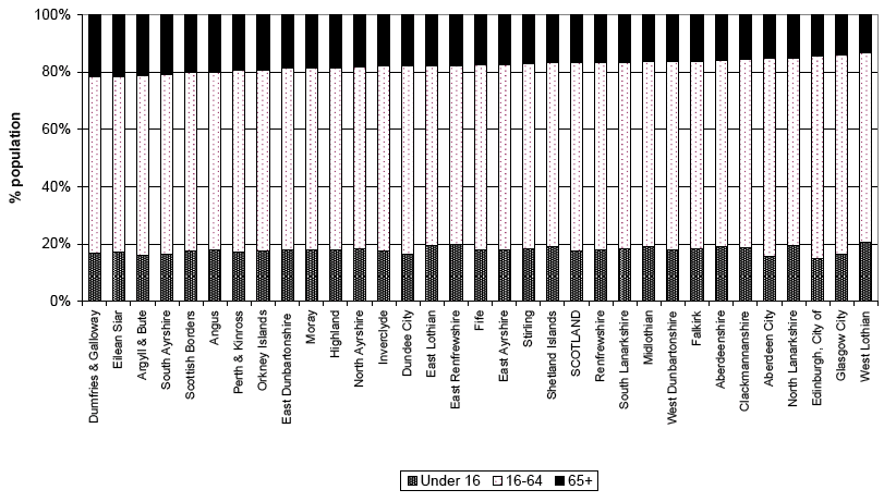
Figure 9 Age structure of NHS Board areas, 30 June 2009 (% under 16, 16-64 and 65+), (ranked by percentage aged 65+)