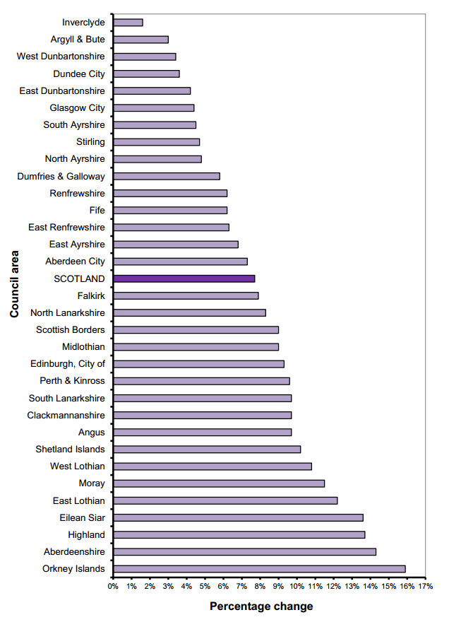
Figure 5 shows how the number of households has grown in every Council area
over the last ten years. The areas with the greatest increase, in percentage terms,
have been the Orkney Islands (an increase of 15.9 per cent, 1,362 households) and
Aberdeenshire (an increase of 14.3 per cent, 13,364 households). The City of
Edinburgh has seen the largest increase in terms of absolute numbers (19,241
households, an increase of 9.3 per cent) (Table 1).
Figure 5: Percentage change in the number of households, by Council area in Scotland, 2003 to 2013
Over the last year, the number of households has increased in every Council area
except West Dunbartonshire, which decreased by just nine households.
Most Council areas saw an increase in the total number of dwellings between 2012
and 2013 (Table 2). However, in Inverclyde and Dundee City there was a fall in the
number of dwellings (by 799 and 258 properties, respectively). This was due to
recent demolitions of properties.
3.2 Vacant dwellings and second homes
Tables 7, 8, 9a, 9b and 10 describe characteristics of dwellings:
Across Scotland, 2.8 per cent of dwellings were vacant and 1.4 per cent were
second homes, though there is wide variation across the country. Vacant
dwellings include new homes which are yet to be occupied and dwellings which
are empty and awaiting demolition, amongst others.
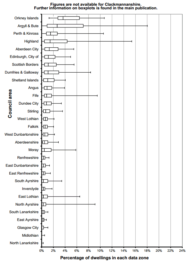
The percentage of dwellings in each Council area which are vacant are highest
in the Orkney Islands (5.7 per cent) and Argyll & Bute (5.0 per cent).
Argyll and Bute is the Council area with the highest percentage of second
homes (6.3 per cent) followed by Eilean Siar (6.3 per cent), the Orkney Islands
(4.7 per cent) and Highland (3.9 per cent). As may be expected, there are high
numbers of second homes in the National Parks (12.1 per cent of all dwellings in
Cairngorms National Park and 6.5 per cent in Loch Lomond and the Trossachs,
compared to the Scottish average of 1.4 per cent).
The Scottish Government has introduced new regulations1 which allow councils
to increase the Council Tax charges on certain long-term empty properties. As a
result of this, some councils have carried out reviews of which properties are
classified as being vacant or second homes. This has led to a fall in the
numbers being classed as vacant dwellings or second homes, between 2012 to
2013.
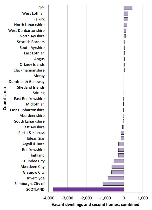
Figure 6 shows that the areas with the biggest decreases in dwellings classed
as being vacant or second homes were the City of Edinburgh, Inverclyde,
Glasgow City, Aberdeen City and Dundee City (from -1,123 in the City of
Edinburgh to -536 in Dundee City). The biggest increases were in Fife, West
Lothian and Falkirk (+443, +214 and +213, respectively). These councils had all
carried out reviews of the properties that were recorded in their Council Tax
systems as being long-term empty or second homes, which resulted in
significant changes between the 2012 and 2013 figures.
Figure 6: Change in the number of vacant dwellings and second homes, combined, in each Council area in Scotland, September 2012 to 2013
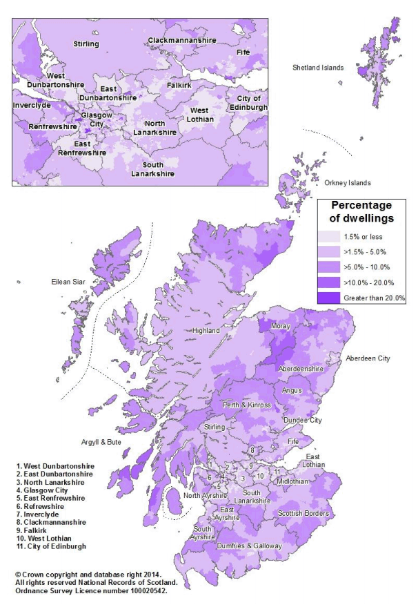
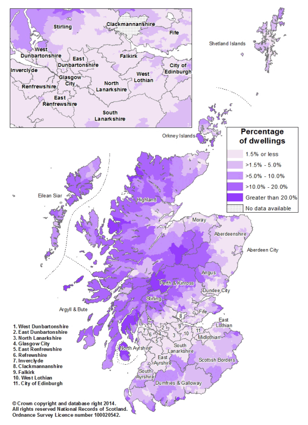
There is also variation within each Council area as illustrated in the maps in
Figure 7 and Figure 8, and the boxplots in Figure 11 and Figure 12.
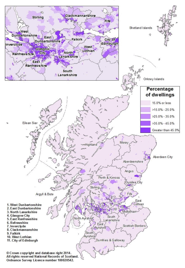
For example, although the highest numbers of vacant dwellings are in rural
council areas such as Eilean Siar, there are parts of Inverclyde, Glasgow City
and West Dunbartonshire which have more vacant dwellings.
Another illustration is that North Ayrshire includes the island of Arran, which has
quite high numbers of second homes, whereas the mainland part of North
Ayrshire has very few.
Figure 7: Percentage of dwellings which are vacant in each data zone in Scotland, 2013 (Map)
Figure 8: Percentage of dwellings which are second homes in each data zone in Scotland, 2013 (Map)
3.3 Property type and density of housing
Tables 3, 4, 5 and 6 describe property type and density of housing:
There is wide variation in dwelling types across Scotland. The map in Figure 9
illustrates this, showing that there are far more flats in the urban areas, as
expected. There are also more flats in areas with higher levels of deprivation.
In Scotland, the number of dwellings can vary tremendously from area to area.
The density of housing increases from an average of 0.03 dwellings per hectare
in remote rural areas to an average of 10.49 dwellings per hectare in large
urban areas. When averaged for Scotland as a whole, the figure is 0.32
dwellings per hectare.
Glasgow City has the highest average density of housing of all Council areas
(16.96 dwellings per hectare) followed by Dundee City (12.25 dwellings per
hectare). Highland has the lowest density of housing, with an average of 0.04
dwellings per hectare, closely followed by Eilean Siar, which has an average of
0.05 dwellings per hectare.
Figure 9: Percentage of dwellings which are flats in each data zone in Scotland, 2013 (Map)
3.4 All-student households
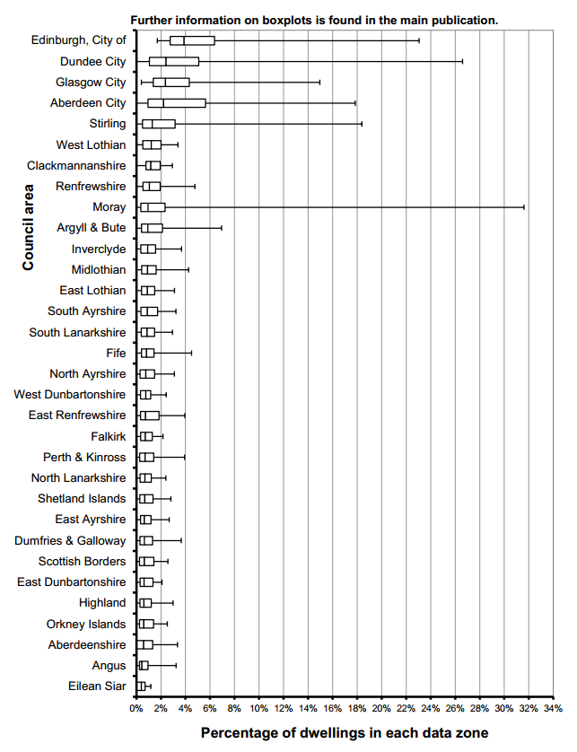
Some dwellings are occupied, but exempt from paying Council Tax. Most of
these are all-student households, though there are some other types of
dwellings which are included in this category, such as armed forces
accommodation.
The figures tend to be highest in the Council areas which have major
universities, and therefore large student populations. They also tend to be quite
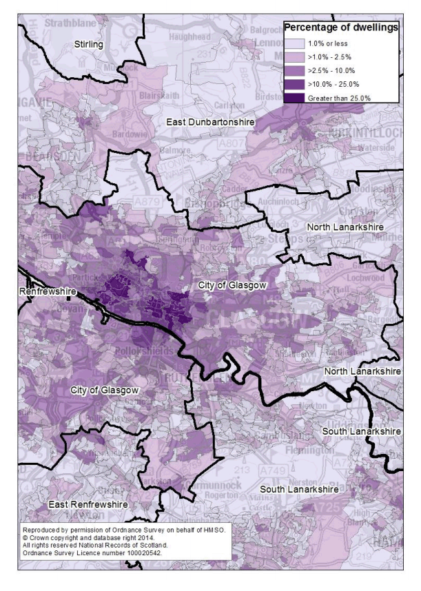
concentrated within certain parts of these Council areas. Figure 10 illustrates
this, by showing the percentage of dwellings in each data zone in Glasgow City
which are occupied but exempt from paying Council Tax - this shows the areas
which have large numbers of all-student households.
Figure 10: Percentage of dwellings with 'occupied exemptions' (e.g. all-student households) in each data zone, in Glasgow City in 2013 (Map)
3.5 Household size
Average household sizes are falling, as more people live alone or in smaller
households, though the rate of change is slowing down, as shown in Figure 3.
The average household size decreased over the last decade, from 2.23 people
per household in 2003, to 2.18 in 2013.
Table 11 shows the average household size by Council area in Scotland from
2001 to 2013. In 2013, average household size varied from 2.03 people per
household in Glasgow City to 2.40 people per household in East Renfrewshire.
All Council areas saw a decrease in average household size over the last
decade, with the exception of Aberdeen City, where there was almost no
change. The amount of decrease varied widely, with the biggest change in
Eilean Siar, where average household size fell from 2.29 in 2003 to 2.09 in
2013.
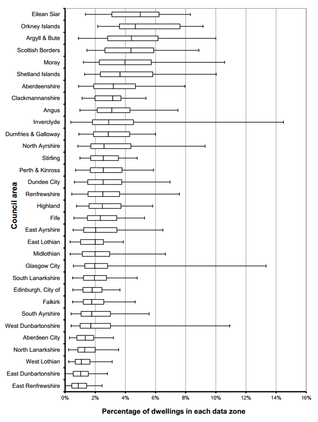
3.6 Box plots showing variation within Council areas
A way of illustrating the variation within a Council area is through the use of
boxplots. Boxplots show a ranked set of data values, grouped. Figures 11, 12, 13
and 14 use boxplots ranked by median (showing middle value). The larger the box,
the more variation there is within that Council area. An illustration of a boxplot is
shown below.
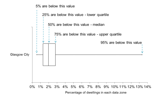
Example of a box plot:
Percentage of dwellings that are vacant in data zones in Glasgow City, 2013
The example above shows the percentage of dwellings that are vacant in each data
zone in Glasgow City (from Figure 11). In half of the data zones in Glasgow City
(the median), fewer than two per cent of the dwellings are vacant. However, there
are some data zones with far more vacant dwellings.
Various regeneration projects are taking place across Glasgow. These often involve
dwellings lying vacant whilst awaiting demolition or repair work.
Figure 11: Percentage of dwellings in each data zone which are vacant in each Council area, September 2013
Figure 12: Percentage of dwellings in each data zone which are second homes in each Council area, September 2013
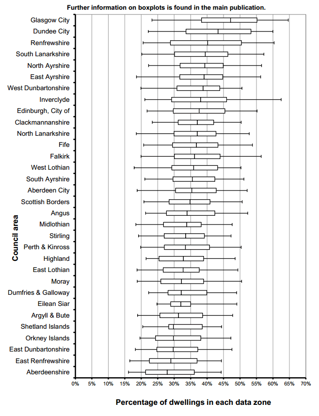
Figure 13: Percentage of dwellings in each data zone with a 'single adult' discount from Council Tax in each Council area, September 2013
Figure 14: Percentage of dwellings in each data zone with 'occupied exemptions' from Council Tax (e.g. all-student households or armed forces accommodation) in each Council area, September 2013