This report gives the General Register Office for Scotland’s forward projection of the number of households in Scotland’s National Parks and Strategic Development Plan (SDP) areas. The forward projections are given up to the year 2033, based on the estimated population of these areas in mid-2008. The projections are trend-based and do not, for example, take account of future policy.
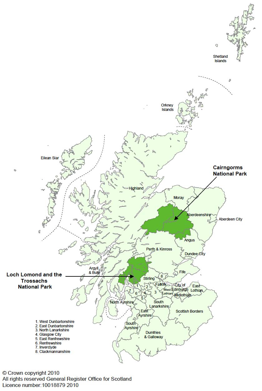
National Parks are protected areas of beautiful countryside, wildlife and cultural heritage. There are two National Parks in Scotland: Loch Lomond and the Trossachs National Park (LLTNP), and Cairngorms National Park (CNP). The locations of the National Parks are shown on Map 1. Each National Park is managed by a National Park Authority.
Table A gives information on the population and the number of households in the National Parks. These populations are quite small and forward projections for such small populations are less reliable, especially for the distant future, than those for larger communities.
Table A: Total populations and households in the National Parks in 2008
| Population | Households | Percentage of Scotland total | ||
|---|---|---|---|---|
| Population | Households | |||
| Cairngorms | 16,430 | 7,700 | 0.3% | 0.3% |
| Loch Lomond and the Trossachs | 14,590 | 6,250 | 0.3% | 0.3% |
| Rest of Scotland | 5,137,480 | 2,317,300 | 99.4% | 99.4% |
| Scotland | 5,168,500 | 2,331,250 | 100.0% | 100.0% |
All figures are rounded to the nearest 10.
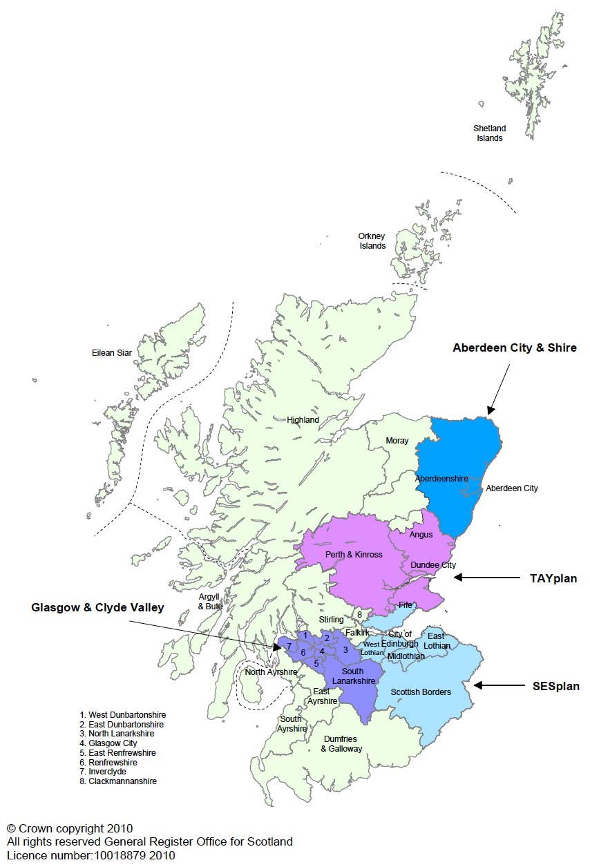
SDP areas (Map 2) cover the regions around Aberdeen, Dundee, Edinburgh and Glasgow. Three quarters of the population of Scotland live in these areas. SDP areas were designated in November 2008 as the area for which a SDP should be prepared by the Strategic Development Planning Authority.
They comprise:
Aberdeen City and Shire Strategic Development Plan Area
(Aberdeen City & Shire SDP area)
Aberdeen City and Aberdeenshire council areas (except the part
of Aberdeenshire that forms part of Cairngorms National Park).
Glasgow and the Clyde Valley Strategic Development Plan Area
(Glasgow & Clyde Valley SDP area)
East Dunbartonshire, East Renfrewshire, Glasgow City,
Inverclyde, North Lanarkshire, Renfrewshire, South Lanarkshire and
West Dunbartonshire council areas (except the part of West
Dunbartonshire that forms part of Loch Lomond and the Trossachs
National Park).
Edinburgh and South East Scotland Strategic Development Plan
Area (SESplan SDP area)
City of Edinburgh, East Lothian, Midlothian, Scottish Borders,
West Lothian and Fife (Kirkcaldy, Mid-Fife and Dunfermline local
planning areas only) council areas.
Dundee, Perth, Angus and North Fife Strategic Development
Plan Area (TAYplan SDP area)
Angus (except the part of Angus that forms part of Cairngorms
National Park), Dundee City, Perth & Kinross (except the part
of Perth & Kinross that forms part of Loch Lomond and the
Trossachs National Park) and Fife (St Andrews and North Fife local
planning areas only) council areas.
Table B gives information on the population and the number of households in SDP areas.
Table B: Total populations and households in SDP areas in 2008
| Population | Households | Percentage of Scotland total | ||
|---|---|---|---|---|
| Population | Households | |||
Aberdeen City & Shire |
448,690 | 202,910 | 9% | 9% |
| Glasgow & Clyde Valley | 1,752,950 | 794,440 | 34% | 34% |
| SESplan | 1,213,910 | 543,620 | 23% | 23% |
| TAYplan | 475,190 | 215,880 | 9% | 9% |
Rest of Scotland |
1,277,760 | 574,400 | 25% | 25% |
| Scotland | 5,168,500 | 2,331,250 | 100% | 100% |
All figures are rounded to the nearest 10.
Further details of National Park and SDP boundaries are given in Section 4, and in Maps 3 and 4. More information about SDP areas is available from the Scottish Government’s Planning Circular 3/08: http://www.scotland.gov.uk/Publications/2008/11/25145654/15
Any boundary change as the result of the Scottish Natural Heritage public consultation (running from 6th March to 31st May 2010) to extend Cairngorms National Park into Perth & Kinross council area has not been included in this publication, as the consultation period had not finished at the time of publication of the 2008-based population projections for National Parks and SDP areas.
These household projections are mainly used to help assess housing needs and future demand.
Map 1: Map of Scotland showing the locations of CNP and LLTNP
Map 2: Map of Scotland showing the locations of SDP areas